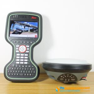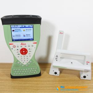
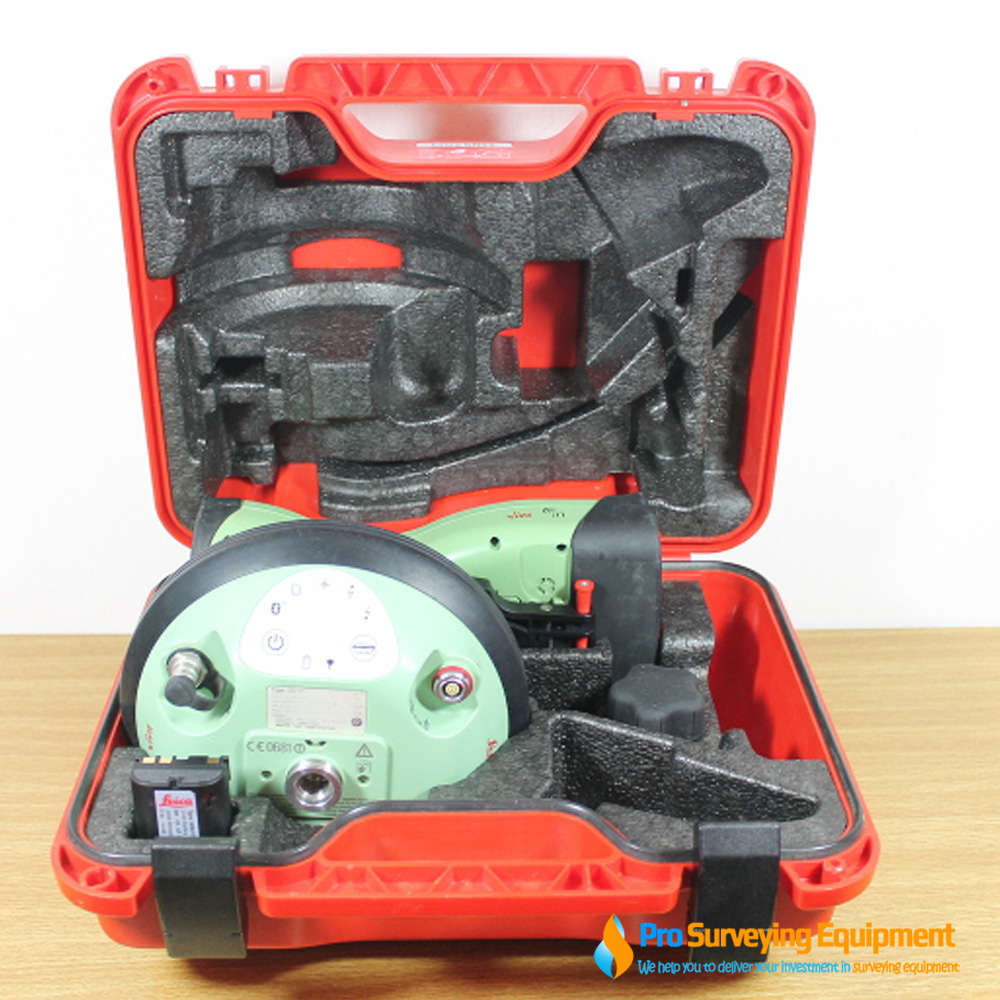
Gently used year 2017 Leica Viva GS14 CS15, everything is still in excellent working order condition. Fully tested, serviced by Leica Factory Trained Technicians to ensuring optimal performance and accuracy, meets manufacturer specifications and works flawlessly with Leica working standards.
Package includes:
The Leica Viva GS14 is a compact and powerful GNSS smart antenna, suited for any measuring task with integrated mobile communications and UHF modem. The Leica Viva GS14 is easy-to-use with its convenient and integrated design. This smart antenna is your all-around GNSS instrument for professional reliability when you need the most demanding accuracy. The Viva GS14 is designed to perform wherever, whenever you need.
The Viva GS14 also delivers with:
Specifications:
| Weight & Dimensions | |
| Weight (GS15) | 1.34 kg |
| Weight | 3.30 kg standard RTK rover including slot RTK device, controller, batteries pole and bracket |
| Dimension (GS15) (diameter x height) | 196 mm x 198 mm |
| Environmental specifications |
|
| Temperature, operating | –40° C to +65° C, compliance with ISO9022-10-08, ISO9022-11-special, MIL STD 810F – 502.4-II, MIL STD 810F – 501.4-II |
| Temperature, storage | –40° C to +80° C, compliance with ISO9022-10-08, ISO9022-11-special, MIL STD 810F – 502.4-II, MIL STD 810F – 501.4-II |
| Humidity | 100%, compliance with ISO9022-13-06, ISO9022-12-04 and MIL STD 810F – 507.4-I |
| Proof against: water, sand and dust | IP68 according IEC60529 and MIL STD 810F – 506.4-I, MIL STD 810F – 510.4-I and MIL STD 810F – 512.4-I Protected against blowing rain and dust Protected against temporary submersion into water (max. depth 1,4 m) |
| Vibration | Withstands strong vibration during operating, compliance with ISO9022-36-08 and MIL STD 810F – 514.5-Cat.24 |
| Drops | Withstands 1.0 m drop onto hard surfaces |
| Functional shock | 40 g / 15 to 23 msec, compliance with MIL STD 810F – 516.5-I No loss of lock to satellite signal when used on a pole set-up and submitted to pole bumps up to 150 mm |
| Topple over | Withstands topple over from a 2 m survey pole onto hard surfaces |
| Power & Electrical | |
| Supply voltage | Nominal 12 V DC Range 10.5 – 28 V DC |
Power consumption |
Typically: 3.2 W, 270 mA |
| Internal power supply | Recharge & removable LI-Ion battery, 2.6 Ah / 7.4 V, 2 batteries fit into receiver |
| Internal power supply, operation time | • 10.00 h receiving RTK data with standard radio • 9.00 h transmitting RTK data with standard radio • 7.50 h RTK via GSM/GPRS connection using 2 internal batteries |
| External power supply | Rechargeable external NiMh battery 9 Ah / 12 V |
| Certifications | Compliance to: FCC, CE Local approvals (as IC Canada, C-Tick Australia, Japan, China) |
| Memory | |
| Memory medium | Removable SD Card: 1 GB |
| Data capacity | 1 GB is typically sufficient for about GPS & GLONASS (8+4 satellites) 280 days raw data logging at 15 s rate |
| Data recording | |
| Type of data | Onboard recording of: • Leica GNSS raw data • RINEX data |
| Recording rate | Up to 20 Hz |
| Buttons | • ON / OFF button • Function button |
| Button functionality | Function button: • Easy switch between Rover / Base mode • Easy “Here” positioning functionality |
| Led status indicator | Bluetooth®, position, RTK status, data logging, detailed power status |
| Additional user interface | Additional web interface functionality provides full status indicator and configuration options |
| Communications | |
| Communication ports | 1 x serial RS232 Lemo 1 x USB / RS232 Lemo 1 x UART serial & USB (for removable internal RTK devices) 1 x Bluetooth® port, Bluetooth® v2.00+ EDR, class 2 |
| No. of simultaneous data links | • Up to 3 data links can be attached and used simultaneously • 2 real-time output interfaces via independent ports, providing identical or different RTK/ RTCM formats |
Built In data links |
|
| Radio modems | • Fully integrated, fully sealed receive / transmit radios • User exchangeable device • SATEL, Pacific Crest and others • 390 – 470 MHz bandwidth • Transmit power: 0.5 – 1.0 W |
| Radio modems | • Fully integrated, fully sealed receive / transmit radios • User exchangeable device • SATEL, Pacific Crest and others • 390 – 470 MHz bandwidth • Transmit power: 0.5 – 1.0 W |
| UHF antenna options | • Fully integrated UHF antenna • External UHF antenna connector (Type QN) |
| 3G GSM / UMTS(HSDPA) phone modem | • Fully integrated, fully sealed phone modem • User exchangeable device • User exchangeable SIM card • Tri-Band UMTS / HSDPA: 850 / 1900 / 2100 MHz • Quad-Band GSM / GPRS: 850 / 900 / 1800 / 1900 MHz |
| CDMA phone modem | • Fully integrated, fully sealed CDMA phone modem • User exchangeable device • Dual-Band CDMA 1XRTT (800 / 1900 MHz) |
| GSM / UMTS / CDMA antenna options | • Integrated GSM / UMTS / CDMA antenna • External GSM / UMTS / CDMA antenna connector (Type QN) |
External data links |
|
| Radio modems | Support of any suitable UHF / VHF radio |
| GSM / UMTS / CDMA phone modems | Support of any suitable GSM / GPRS / UMTS / CDMA modem |
| Landline phone modems | Support of any suitable Landline phone modem |