Lightly used year 2018 and everything is still in excellent working order condition. Fully tested, serviced by Leica Factory Trained Technicians to ensuring optimal performance and accuracy, meets manufacturer specifications and works flawlessly with Leica working standards.
This Leica GS16 CS20 GNSS RTK Rover sold as is with 6-month warranty and we offer 30 days money back guarantee of your purchase
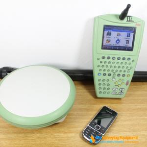
Package includes:
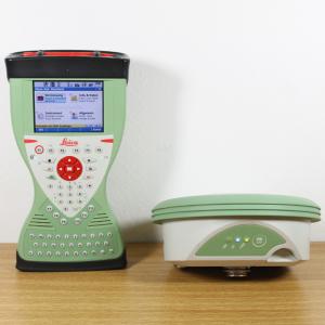
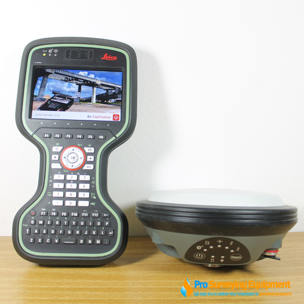
Leica Viva GS16 GNSS Smart Antenna Receive
The Leica Viva GS16 is a powerful self-learning GNSS smart antenna. The growing number of signals from ever-increasing satellite constellations demands the GNSS receiver to be smart and reliable. The GS16 is a solid measurement companion for surveyors who need a survey-proof GNSS system that is light to carry anywhere but handles even the most challenging measurement conditions. The GS16 is a smart solution – Use it as a rover or as a trustworthy base.
The Leica Viva GS16 GNSS smart antenna is accompanied with the revolutionary Captivate software, turning complex data into the most realistic and workable 3D models. With easy-to-use apps and familiar touch technology, all forms of measured and design data can be viewed in all dimensions. Leica Captivate spans industries and applications with little more than a simple swipe, regardless of whether you work with GNSS, total stations or both. Leica Infinity imports and combines data from your GNSS, total station and level instruments for one final and accurate result. Processing has never been made easier when all your instruments work in tandem to produce precise and actionable information
Pair with the Leica CS20 controller or Leica CS30 tablet with L2, L5, L-band tracking plus GLONASS (optional Galileo and BeiDou available) paired with a Leica CS20 controller with Leica Captivate SW- Measure and Stakeout to achieve the ultimate in control and convenience with complete mobility. Touch screen technology allows for comfortable and quick data processing while a stunning 3D view transforms your Leica Viva GNSS experience.
FEATURES
RTKplus
SMARTCHECK
SMARTLINK
BUILT FOR THE MOST DEMANDING ENVIRONMENTS
ERGONOMICS
ONLINE SERVICES
SPECIFICATIONS
| GNSS TECHNOLOGY | |
| Self-learning GNSS | Adaptive on-the-fly satellite selection Remote precise point positioning (3 cm 2D)1 Initial convergence to full accuracy 20 - 40 min, Re-convergence < 1 min Bridging of RTK outages up to 10 min (3 cm 2D) |
| Leica SmartCheck | Reliability 99.99% |
| Signal tracking | GPS (L1, L2, L2C, L5), Glonass (L1, L2, L32), BeiDou (B1, B2, B32), Galileo (E1, E5a, E5b, Alt-BOC, E62), QZSS (L1, L2, L5, LEX2), NavIC L53, SBAS (WAAS, EGNOS, MSAS, GAGAN), L-band |
| Number of channels | 555 (more signals, fast acquisition, high sensitivity) |
| MEASUREMENT PERFORMANCE & ACCURACY | |
| Time for initialisation | Typically 4 s |
| Real-time kinematic (Compliant to ISO17123-8 standard) | Single baseline: Hz 8 mm + 1 ppm / V 15 mm + 1 ppm Network RTK: Hz 8 mm + 0.5 ppm / V 15 mm + 0.5 ppm |
| Post processing | Static (phase) with long observations: Hz 3 mm + 0.1 ppm / V 3.5 mm + 0.4 ppm Static and rapid static (phase): Hz 3 mm + 0.5 ppm / V 5 mm + 0.5 ppm |
| Code differential | DGPS / RTCM: Typically 25 cm |
| COMMUNICATIONS | |
| Communication ports | Lemo: USB and RS232 serial Bluetooth: Bluetooth® v2.00 + EDR, class 2 |
| Communication protocols | RTK data protocols: Leica, Leica 4G, CMR, CMR+, RTCM 2.2, 2.3, 3.0, 3.1, 3.2 MSM NMEA output: NMEA 0183 V 4.00 and Leica proprietary Network RTK: VRS, FKP, iMAX, MAC (RTCM SC 104) |
| Built-in data links | 3.75G GSM / UMTS / CDMA phone modem Radio modem: Fully integrated, internal antenna Fully integrated, receive and transmit, external antenna 403 - 470 MHz, 1 W output power, up to 28800 bps over air |
| External data links | GSM / GPRS / UMTS / CDMA and UHF / VHF modem |
| GENERAL | |
| Field controller and software | Leica Captivate software Leica CS20 field controller, Leica CS35 tablet |
| User interface | Buttons and LEDs: On / Off and Function button, 7 status LEDs Web server: Full status information and configuration options |
| Data recording | Storage: Removable microSD card, 8 GB Data type and recording rate: Leica GNSS raw data and RINEX data at up to 20 Hz |
| Power management | Internal power supply: Exchangeable Li-Ion battery (2.6 Ah / 7.4 V) External power supply: Nominal 12 V DC, range 10.5 - 28 V DC Operation time: 7 h receiving (Rx) data with internal radio, 5 h transmitting (Tx) data with internal radio, 6 h Rx / Tx data with internal phone modem |
| Weight and dimensions | Weight: 0.93 kg / 3.20 kg standard RTK rover setup on pole Diameter x Height: 190 mm x 90 mm |
| Environmental | Temperature: -40 to 65°C operating, -40 to 80°C storage Drop: Withstands topple over from a 2 m survey pole onto hard surfaces Proof against water, sand and dust: IP68 (IEC60529 / MIL STD 810G 506.5 I / MIL STD 810G 510.5 I / MIL STD 810G 512.5 I) Vibration: Withstands strong vibration (ISO9022-36-08 / MIL STD 810G 514.6 Cat.24) Humidity: 100% (ISO9022-13-06 / ISO9022-12-04 / MIL STD 810G 507.5 I) Functional Shock: 40 g / 15 to 23 msec (MIL STD 810G 516.6 I) |
Quick Step by Step Guide of Leica GS16 GNSS Receiver and CS20 Data Controller with Captivate software
This is quick step guide to help users power on GS16 with CS 20 Data Collector using Captivate software. It a step by step procedures to check communication between GS16 and DC. Verify internet status and getting RTK corrections.

From the Captivate SW, Top row Task Bar, Select/tap on the Cellphone icon, ![]() then Select / tap “Start RTK Stream”, the Network RTK Rover will connect to the Network Server/Mount Point; wait a few seconds for the GS16 Network RTK Rover to compute a RTK Fixed Solution…
then Select / tap “Start RTK Stream”, the Network RTK Rover will connect to the Network Server/Mount Point; wait a few seconds for the GS16 Network RTK Rover to compute a RTK Fixed Solution…
From the Captivate SW, Top Row Task Bar, look at the Position Status icon,
This Position Status icon indicates an RTK Float Solution, The Position Status LED on the GS16 GNSS Receiver will be blinking GREEN.
From the Captivate SW, Top Row Task Bar, look at the Position Status icon,
This Position Status icon indicates an RTK Fix Solution, The Position Status LED on the GS16 GNSS Receiver will be solid GREEN.
The Network RTK Rover now has a Fixed RTK Position, the User can start the Measure Points, Stake Points, 3D Viewer APPS…
At the conclusion of the Network RTK Rover Survey, from the Captivate SW, Top Row Task Bar select/tap the Cellphone icon, ![]() , Select “Stop RTK Stream”,
, Select “Stop RTK Stream”,
the Network RTK Rover will disconnect from the Network Server/Mount Point; this will Stop the Network RTK Corrections, the RTK Fix Solution will revert to a RTK Float, eventually deteriorating back to an Autonomous/Navigated Position.
Power OFF the GS16 GNSS Receiver.
Reference